Today dawned chilly and gloomy, but as mid-morning approached, it wasn’t raining, so I decided that I would participate in a scheduled Walktober event at Opacum Woods; I would meet the new Executive Director of Opacum Land Trust and then hike the trails with the Land Trust staff. Now in its 24th year, Walktober is one of the more visible programs co-ordinated by The Last Green Valley, the 35-town National Heritage Corridor in eastern Connecticut and south-central Massachusetts, whose mission is to protect and preserve the natural and cultural resources of the Quinebaug and Shetucket Rivers watershed.
Opacum Land Trust, the sponsor of this Walktober event, was founded in 2000 and now protects about 1000 acres of land in 13 southern Worcester County towns. An all-volunteer land trust, Opacum hired its first paid staff person, Ed Hood, earlier this year. A resident of Hardwick, he is well-known for his leadership at Old Sturbridge Village, one of the most popular tourist destinations in our region and also an outstanding resource for historical preservation and educational programming.
Shortly before 10 am, a group of about 35 of us gathered at the Opacum Woods trailhead, which, incongruously enough, is off a cul-de-sac in a housing development close to where the Mass Pike and I-84 intersect. This being an election year, both Representative Todd Smolar and Representative Anne Gobi joined the group. After Ed Hood welcomed us, we walked into the woods a short distance to the site of a new bridge over one of the streams that criss-cross the property. To fulfill a requirement for attaining Eagle Scout rank, Sturbridge teen Logan Melican took on the project of constructing this bridge, and I must say, I was quite impressed with his work! In June of this year, along with some other volunteers, I helped Logan demolish the old bridge and carry away the rotting timbers. At the time, I figured him for a shy kid who might struggle with leadership tasks, but today, he spoke fluently and confidently about the project. In this photo, from left to right are Howie Fife, Anne Gobi, Todd Smolar, Logan Melican ready to cut the ribbon, Logan’s father, and Ed Hood off to the side.

Land Trust officers Howie Fife and Alan Smith then led us out on the Blue Trail loop, discussing points of interest with us as we walked along. We were all given trail maps so we could orient ourselves; this map is a draft version which will be finalized after more feedback from hikers is received and incorporated (Southbridge Savings Bank has graciously underwritten publication of the map and brochure). As I learned more about the property, I realized that the Land Trust must have been thrilled to add these 266 acres, donated by Robert Moss and Brendon Properties in 2003, to their portfolio of conservation land.
The state-listed Marbled Salamander, Ambystoma opacum, for which the Trust is named, is well-documented as breeding on this property. Other state-listed species, documented by a team from the New England Wildflower Society which surveyed the property in 2008, include the Grape Fern (Ophioglossum pusillum) and the Bristly Buttercup (Ranunculus pensylvanicus).
The property’s southern boundary runs briefly parallel to Route 20, which overlays an older Native American trail which ran east-west across the state; it’s not a surprise that we walked past a rock shelter, where Native Americans would stop to rest on their journeys.
This feature is a boulder, not an erratic, because in geologic composition it is similar to the bedrock below it. In contrast, a glacial erratic, as one might surmise from its name, is distinct from the surrounding rocks.
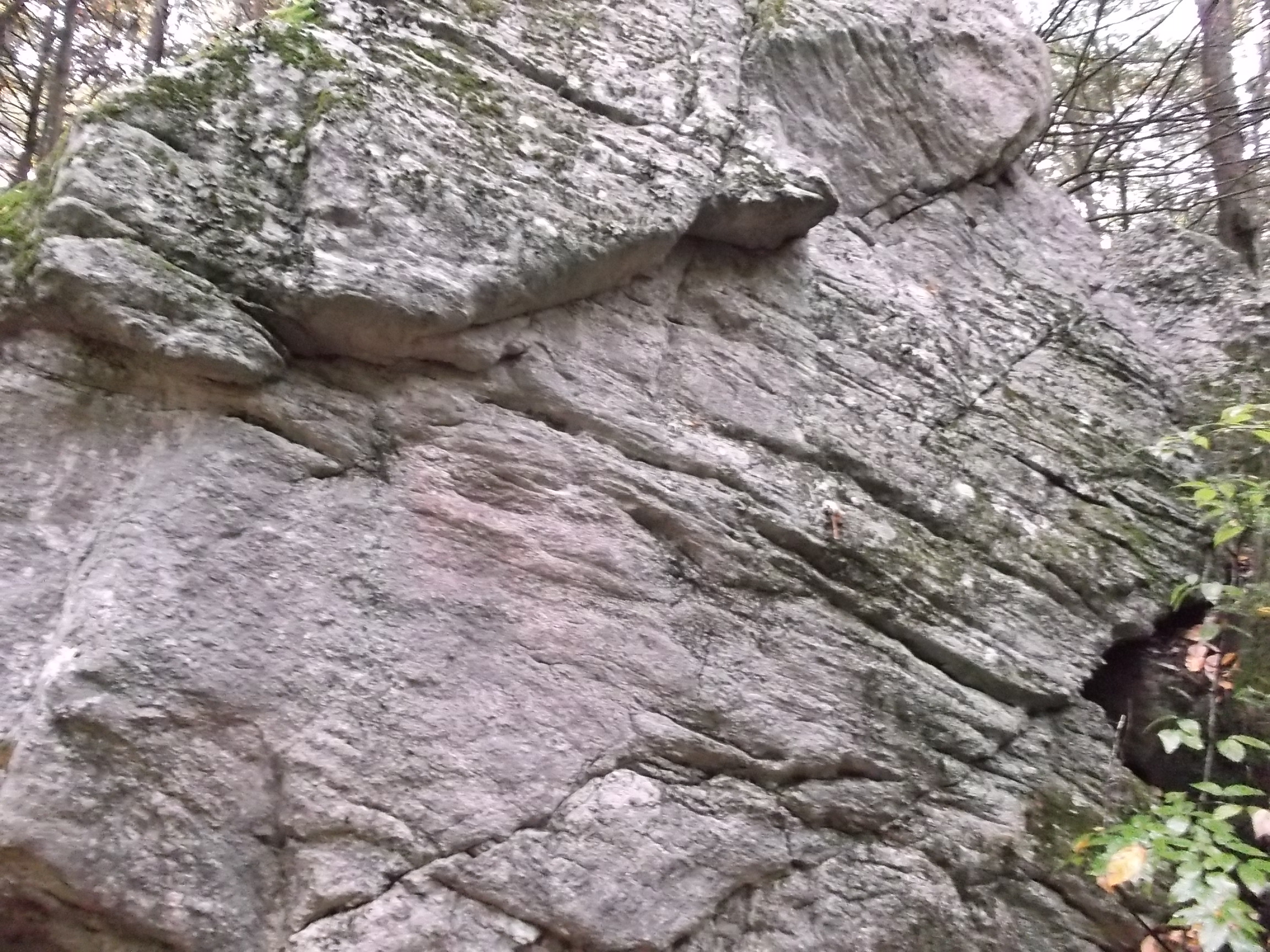
What we’re looking at here are features of a thrust-faulted landscape. Between 425 and 370 million years ago, the Laurentian continent collided with the Gondwana continent, right here. Consequently, a lot of rock in this area is granite gneiss or schist, which are metamorphic.

One of the outstanding features here is Opacum Pond; it harbors some busy beavers. This tree was probably chewed up last night!

The dominant trees here are oaks; there are some stands of hemlock and maple, as well as three types of hickory (shagbark, shellbark, and pignut). At one point not so long ago, timber was harvested from tracts near the property. For example, American Optical Company in Southbridge managed their own forest lands in order to supply their factories with wood products. The species of trees now prevalent in an area may be a clue to previous land use, such as for farm plots or pasture, and also an indication of a particular stage in forest succession. For example, the hurricane of 1938 had a tremendous impact on the New England landscape; in areas previously dominated by white pine, foresters noted the quick emergence of hemlock, then pin cherry, then red maple and white ash, then finally red oak.
What I’m gazing at is the remnant of a colonial-era road, built in 1738 to exacting specifications, namely, it was 32 feet, or 2 rods, wide, with a 5% grade. The road was intended to connect with the county gore — yes, that is the term for a “thin triangular piece of land, the boundaries of which are defined by surveys of adjacent properties.” (I wasn’t familiar with the term and had to look it up.) On the trail map, this path is listed as Walker Mountain Road; parts of the Blue, the Yellow, and the Red Trails have been blazed along this road.

About twenty vernal pools have been documented on the property; we didn’t see any on our walk, because fall is not the season when they can be observed. Around the mid-point of the Blue Trail loop, the hike leaders pointed out the location where a large pool would be found in the spring.
Although it sprinkled on and off throughout the morning, the trees we walked under were still in leaf and kept us mostly dry until we arrived back at the parking area shortly after noon. I’m glad I took this opportunity to explore a landscape rich in nature and history so close to my home.