A few months ago, on a whim, I decided to order the Geno 2.0 kit from National Geographic (the company was offering a discount on the product). Within a few days, I received my kit in the mail, and on our Monday holiday in November, I started the process. I probably watch too many cop shows on TV, but I felt like a criminal as I swabbed DNA from the inside of my mouth. Fortunately, it’s not that hard to do, and the next day, I sent my samples off in the envelope provided.
One has to wait at least six to eight weeks for the DNA analysis to be complete; when I checked a few weeks ago, my sample was being validated. Finally, today, I was able to log in to the website and read my results. Perhaps it’s something innate in human beings — I mean this curiosity about where we come from– but I must say I was thrilled when I saw it confirmed on my laptop that I really am a part of the greatest story ever told.
The Genographic Project is the brainchild of Dr Spencer Wells, a charismatic population geneticist, author, and documentary filmmaker. Born in 1969 in Marietta, Georgia, he completed his doctorate in biology in 1994, under Richard Lewontin at Harvard University, and subsequently worked with both Luigi Cavalli-Sforza and Walter Bodmer.
Since 2005, he has directed this genome project, undertaken under the auspices of the National Geographic Society and with support from IBM and the Waitt Family Foundation. Using advanced DNA analysis, Dr Wells and his colleagues have worked with indigenous communities to help answer fundamental questions about where humans originated and how we came to populate the Earth. If you listen to his Ted talk, you’ll probably want to participate too!
How does this DNA stuff work? The following explanation is a paraphrase from the website:
Each of us carries DNA that is a combination of genes passed from both our mother and father. As part of this process, the Y-chromosome is passed directly from father to son, unchanged, from generation to generation down a purely male line. Mitochondrial DNA, on the other hand, is passed from mothers to their children, but only their daughters pass it on to the next generation.
The DNA is passed on unchanged, unless a mutation — a random, naturally occurring, usually harmless change — occurs. The mutation, known as a marker, acts as a beacon; it can be mapped through generations because it will be passed down for thousands of years.
When geneticists identify such a marker, they try to figure out when it first occurred, and in which geographic region of the world. Each marker is essentially the beginning of a new lineage on the family tree of the human race. Tracking the lineages provides a picture of how small tribes of modern humans in Africa tens of thousands of years ago diversified and spread to populate the world.
So, what’s my story? Well, like every other human being, I’m descended from a common East African ancestor who lived around 180,000 years ago (“Mitochondrial Eve”). After that,
Marker L3 – 67,000 years ago: My L3 ancestors became the first first modern humans to leave Africa, representing the deepest branches of the tree found outside of that continent.
Marker N – 60,000 years ago: Haplogroup N comprises one of two groups that were created by the descendants of L3. It is considered a western Eurasian group, and almost all of the mitochondrial lineages found in the Near East and Europe descend from N.
Marker R – 55,000 years ago: Members of this group moved out of the Near East in all directions, north, east, west, and even back south. In fact, descendants of this line dominate the European maternal landscape, making up 75 to 95 percent of the lineages there.
Marker R0 – 41,000 years ago: Oddly enough, this R0 haplogroup is found at highest frequency in Arabia. My ancestors were probably the ones who migrated east into Central Asia and northwest into Europe.
Marker HV – 22,350 years ago + or – 7,745: Haplogroup HV is a west Eurasian haplogroup found throughout the Near East, including Anatolia and the Caucasus Mountains of southern Russia and the republic of Georgia. Go figure.
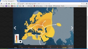
Marker H – 28,000 years ago: Today, haplogroup H comprises 40 to 60 percent of the gene pool of most European populations. However, the age of haplogroup H lineages differs quite substantially between those seen in the West compared with those found in the East. In Europe, its age is estimated at 10,000 to 15,000 years old. In Central and East Asia, its age is estimated at around 30,000 years old, meaning my ancestors made it into those areas during some of the earlier migrations out of the Near East.
So H is my most recent haplogroup; here’s a heat map showing frequency of this group:

The next results show my ancestry percentages as compared with nine reference populations:

My first reference population is Chinese, and my second is German.
So what does this mean in my case?
The website says,
We compared your DNA results to the reference populations we currently have in our database and estimated which of these were most similar to you in terms of the genetic markers you carry. This doesn’t necessarily mean that you belong to these groups or are directly from these regions, but that these groups were a similar genetic match and can be used as a guide to help determine why you have a certain result. Remember, this is a mixture of both recent (past six generations) and ancient patterns established over thousands of years, so you may see surprising regional percentages.
And by the way, the analysis suggests that I have 2.3% Neanderthal genes and 2% Denisovan.


